By Bryan Shuman, Professor of Paleoclimatology and Paleoecology, University of Wyoming Originally published at The Conversation.
When you picture Yellowstone National Park and its neighbor, Grand Teton, the snowcapped peaks and Old Faithful Geyser almost certainly come to mind. Climate change threatens all of these iconic scenes, and its impact reaches far beyond the parks’ borders.
A new assessment of climate change in the two national parks and surrounding forests and ranchland warns of the potential for significant changes as the region continues to heat up.
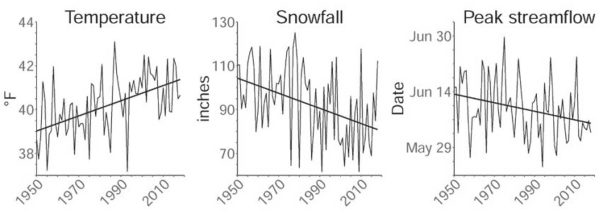
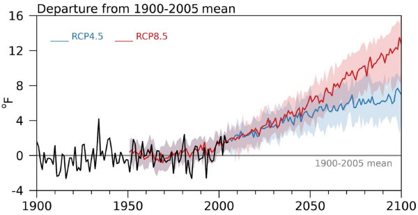
Since 1950, average temperatures in the Greater Yellowstone Area have risen 2.3 degrees Fahrenheit (1.3 C), and potentially more importantly, the region has lost a quarter of its annual snowfall. With the region projected to warm 5-6 F by 2061-2080, compared with the average from 1986-2005, and by as much as 10-11 F by the end of the century, the high country around Yellowstone is poised to lose its snow altogether.
The loss of snow there has repercussions for a vast range of ecosystems and wildlife, as well as cities and farms downstream that rely on rivers that start in these mountains.
Broad impact on Wildlife and Ecosystems
The Greater Yellowstone Area comprises 22 million acres in northwest Wyoming and portions of Montana and Idaho. In addition to geysers and hot springs, it’s home to the southernmost range of grizzly bear populations in North America and some of the longest intact wildlife migrations, including the seasonal traverses of elk, pronghorn, mule deer and bison.
The area also represents the one point where the three major river basins of the western U.S. converge. The rivers of the Snake-Columbia basin, Green-Colorado basin, and Missouri River Basin all begin as snow on the Continental Divide as it weaves across Yellowstone’s peaks and plateaus.
How climate change alters the Greater Yellowstone Area is, therefore, a question with implications far beyond the impact on Yellowstone’s declining cutthroat trout population and disruptions to the food supplies critical for the region’s recovering grizzly population. By altering the water supply, it also shapes the fate of major Western reservoirs and their dependent cities and farms hundreds of miles downstream.
Rising temperatures also increase the risk of large forest fires like those that scarred Yellowstone in 1988 and broke records across Colorado in 2020. And the effects on the national parks could harm the region’s nearly US$800 billion in annual tourism activity across the three states.
A group of scientists led by Cathy Whitlock from Montana State University, Steve Hostetler of the U.S. Geological Survey and myself at the University of Wyoming partnered with local organizations, including the Greater Yellowstone Coalition, to launch the climate assessment.
We wanted to create a common baseline for discussion among the region’s many voices, from the Indigenous nations who have lived in these landscapes for over 10,000 years to the federal agencies mandated to care for the region’s public lands. What information would ranchers and outfitters, skiers and energy producers need to know to begin planning for the future?
Shifting from Snow to Rain
Standing at the University of Wyoming-National Park Service Research Station and looking up at the snow on the Grand Teton, over 13,000 feet above sea level, I cannot help but think that the transition away from snow is the most striking outcome that the assessment anticipates – and the most dire.
Today the average winter snowline – the level where almost all winter precipitation falls as snow – is at an elevation of about 6,000 feet. By the end of the century, warming is forecast to raise it to at least 10,000 feet, the top of Jackson Hole’s famous ski areas.
The climate assessment uses projections of future climates based on a scenario that assumes countries substantially reduce their greenhouse gas emissions. When we looked at scenarios in which global emissions continue at a high rate instead, the differences by the end of century compared with today became stark. Not even the highest peaks would regularly receive snow.
In interviews with people across the region, nearly everyone agreed that the challenge ahead is directly connected to water. As a member of one of the regional tribes noted, “Water is a big concern for everybody.”

As temperature has risen over the past seven decades, snowfall has declined, and peak streamflow shifted earlier in the year across the Greater Yellowstone Area. 2021 Greater Yellowstone Climate Assessment, CC BY-ND
Precipitation may increase slightly as the region warms, but less of it will fall as snow. More of it will fall in spring and autumn, while summers will become drier than they have been, our assessment found.
The timing of the spring runoff, when winter snow melts and feeds into streams and rivers, has already shifted ahead by about eight days since 1950. The shift means a longer, drier late summer when drought can turn the landscape brown – or black as the wildfire season becomes longer and hotter.
The outcomes will affect wildlife migrations dependent on the “green wave” of new leaves that rises up the mountain slopes each spring. Low streamflow and warm water in late summer will threaten the survival of coldwater fisheries, like the Yellowstone cutthroat trout, and Yellowstone’s unique species like the western glacier stonefly, which depends on the meltwater from mountain glaciers.

Temperatures are projected to rise in the Greater Yellowstone Area in the coming decades. The chart shows two potential scenarios, based on different projections of what global warming might look like in the future – RCP 8.5, if greenhouse gas emissions continue at a high rate; and RCP 4.5, if countries take substantial steps to slow climate change. The temperatures are compared with the 1900-2005 average. 2021 Greater Yellowstone Climate Assessment
Preparing for a Warming Future
These outcomes will vary somewhat from location to location, but no area will be untouched.
We hope the climate assessment will help communities anticipate the complex impacts ahead and start planning for the future.
As the report indicates, that future will depend on choices made now and in the coming years. Federal and state policy choices will determine whether the world will see optimistic scenarios or scenarios where adaption becomes more difficult. The Yellowstone region, one of the coldest parts of the U.S., will face changes, but actions now can help avoid the worst. High-elevation mountain towns like Jackson, Wyoming, which today rarely experience 90 F, may face a couple of weeks of such heat by the end of the century – or they may face two months of it, depending in large part on those decisions.
The assessment underscores the need for discussion. What choices do we want to make?


I can only shake my head and ponder that the US west and northwest was only sparsley settled by indigenous populations as civilizations came and went over the eons and recognize that the pattern will continue at the whim of Mother Nature.
There is global warming; I agree with that. And there will be a water shortage in the greater yellowstone area (GYA). But as the report notes:
“GYA is today the fastest-growing rural region in the western US. In 2020, the 20 counties of the GYA had a combined population of nearly 488,000, more than twice the number of residents in 1970 (USCB undated). The recent influx of people and businesses, drawn by the area’s high quality of life, is known as “amenity migration.” Bozeman is the largest city within the GYA boundary, and the fastest growing city of its size in the nation. Most of the region’s smaller cities and towns are also seeing rapid population growth (USCB 2018). At the current rate of growth, Hansen and Phillips (2018) estimated the GYA will have 846,000 residents and over 503,000 homes by 2050. “
Those fossil fuel consumption fests like ordering the US Navy to brush up against other nations eyeballs so we can protect freedom of navigation. Not to mention the environmental impact of for example bombing every inch of Syria for years and years.
Wonder how much that costs. Wonder why our extremely Free Press never asks nor mentions how much that costs? Wonder why no Press folk every ask Biden, Pelosi, McConnell, President Manchin these things? Wonder why it’s never a topic on the Sunday “news” programs or Sixty Minutes or whatever is fashionable now. Wonder why no one in the corporate media asks Americans to ponder how we’d react if China was combing our West Coast and Russia blanketing the Gulf Coast? Wonder how many whales and other highly intelligent animals it kills/injures?
I can only plant so many trees on my yard to balance things out.
The bombing of Syria was mainly conducted by the government of the Syrian Arab Republic. We did not support that.
We ( and not just America) made that necessary by supporting the Cannibal Liver Eating Jihadis against whom the bombing was directed. So one could blame the Global Axis of Jihad ( America, France, Great Britain, Saudi Barbaria, some Gulf Petrostatelets, etc.) for indirectly causing the bombing to go on and on and on . . . . rather than having left the Syrian Arab Republic free and alone to get the Jihadi rebellion exterminated fast, furious and hard.
“The bombing of Syria was mainly conducted by the government of the Syrian Arab Republic.” I’ll just say that’s incorrect and stop there.
If anyone else can demonstrate that most of the aerial bombing was carried out by or on behalf of the Syrian Arab Republic government, I will read any actual factual thing that anyone cares to bring here.
Actually, I meant to write that if anyone can demonstrate that most of the bombing in Syria was NOT carried out by or for the Syrian Arab Republic government, I will read any actual factual evidence about that.
“If anyone else can demonstrate that most of the aerial bombing was NOT carried out by or on behalf of the Syrian Arab Republic government, I will read any actual factual thing that anyone cares to bring here.”
That’s easy. But you might not need to read specific articles, but just use critical thinking, based on this first point alone:
1). Syrian using bombs to defend herself from US aggression plausibly falls into the category of. bombs that the US is responsible for, because US aggression forces Syria to defend herself.
Additionally
2). NC has over time listed and pointed to several links noting the US dropped so many bombs in Syria, America ran out.
3).The US/CIA and it’s allies funded the so called Syrian opposition (better to call them mercenaries and terrorists?).
3). The Russians documented the US scarcely bombed the Syrian opposition and provided extensive figures proving this. It was as if the US was just bowing stuff up. With bombs.
4). There were many reports of US bombing hospitals and relief staff and organizations.
You really don’t need to wonder. The US is run by a ruling class that buys the politicians and controls the corporate media. Thanks to the bought politicians, cable television is controlled by the ruling class. That’s why none of the questions you or I want asked are asked.
I drove past Shasta Lake recently on my way to Oregon. It is dramatic how low it is. California is in serious trouble.
And now there’s a wildfire just north of Mt Shasta. Wildfiretoday.com has the details.
Thanks for the link Alex. Also check Purpleair.com. is worthwhile to follow fires. Here’s the link: https://www.purpleair.com/map?opt=1/mAQI/a10/cC0&select=35081#7.18/40.85/-122.361
Makes me want to sing Prince.
In reading an article in Wildfire today, firefighters were complaining about low pay, understandably. However, don’t get caught for a petty crime, say auto theft. Avoiding a debate on what constitutes “petty”, MOST of California’s firefighters are prison labor making less than $2 per hour. Neo feudalism anyone?
Water= liquid gold. Just wait until everybody starts arguing over water rights, export restrictions and on and on…
Meanwhile, everyone in the Northwest and the Great Lakes should either learn pipeline bombing skills or practice the pipeline bombing skills they already have, for when the SouthWest Water Pirates work to steal all the water from the NorthWest and the Great Lakes with Water Piracy Pipelines.
The paragraph 8 estimate on tourism should be $800 million, not billion. (As per the link)
The US economy is ~$20 trillion. No way tourism in ID, MT and WY is almost 5% of that.
Yeah, it’s bad. One of the carpenters on a job site was telling me last week that snow pack in the Bitterroot Mountains, south of Missoula, was at only 2%(!) of normal. And we’re due for 105 F+ temps next week in NW MT, which is as hot as it ever gets here, and about 7 weeks too early.
Sierra snowpack was 0% normal on June 1st: lowest ever. That means that the snow that fell had already melted and drained off by then.
United States will annex Canada and its water. We won’t put up a fight as long as we can live down south and still have healthcare
But within 10 years, guilllaume, the New US will “modify”, degrade, pollute, and privatize what it takes over times 100 over what Canada has already done. Then, what will it do?
” the New US will “modify”, degrade, pollute, and privatize what it takes over times 100 over what Canada has already done.”
Like the way your Canadian Enbridge degrades, pollutes American waterways like this?
https://en.wikipedia.org/wiki/Kalamazoo_River_oil_spill
Or how the AlbertaCanadian conspirators are conspiring to destroy the climate of the whole earth with your Alberta Tar Dreck? Which you planned to ram by pipeline over the best farmland in America with your Keystone XL?
Another country known for playing the long game is already well along with a stealth annexation. They have superior experience in degrading and polluting, too.
NAWAPA North American Water and Power Alliance
https://en.wikipedia.org/wiki/North_American_Water_and_Power_Alliance
The Water Protectors better practice up on how to bomb pipelines, dams, canals, etc. And how to recruit millions of non-Indians in the target zone to the great survival cause of exterminating every attempt there is to get NAWAPA built.
Canada can pre-empt and short-circuit that possibility by placing itself under Chinese protection and allowing three hundred million or four hundred million Chinese to settle in Canada. That should stop us Americans from trying to annex Canada.
If mainland China utilizes private contractors the way we do, Canada could stack the border with PRC contractors to protect their water resources. I could imagine that hundreds of millions of Chinese immigrants, or hundreds of millions of immigrants of any stripe would be way too much for their economy and safety net to handle.
The only California County that comes to mind that is NOT at serious risk from an UWI fire is San Francisco County.
That’s it.
Drive around the Bay area and look at the fuels.
That’s EVERYTHING that burns when the winds hit 55MPH plus and the fire reaches 2,000 degrees Fahrenheit.
And that’s what you breathe and that’s what lands on the land and the waters…
It is scary dry and it isn’t yet July.
Why will globalisation be an environmental disaster?
Western companies couldn’t wait to off-shore to low cost China, where they could make higher profits.
Maximising profit is all about reducing costs.
China had coal fired power stations to provide cheap energy.
China had lax regulations reducing environmental and health and safety costs.
China had a low cost of living so employers could pay low wages.
China had low taxes and a minimal welfare state.
China had all the advantages in an open globalised world.
Environmentally friendly measures cost money and reduce profit.
The goal is to maximise profit.
Why do firms move to Mexico and export into the US?
Companies prefer Mexico with its cheap labour, lax health and safety standards, and lack of environmental regulations.
They can expose workers to hazardous chemicals and just pump toxic waste straight out into the environment, without incurring the costs associated in dealing with them in an environmentally friendly way.
https://thoughtmaybe.com/maquilapolis-city-of-factories
Every avenue must be explored to reduce costs.
The lower the costs, the higher the profit.
Western leaders didn’t think through the consequences of maximising profit.
They didn’t realise how China was always going to be the winner in an open, globalised world and how globalisation would be an environmental disaster.