Yves here. Those who even casually follow climate change stories have heard of feedback loops like permafrost melts resulting in methane releases that raise carbon levels. This post describes local examples of human activity having an impact on weather at a scale that is measurable on a national basis.
By Kyle Hilburn, Research Scientist in Atmospheric Science, Colorado State University. Originally published at The Conversation
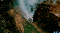
Wildfire blowups, fire whirls, towering thunderstorms: When fires get large and hot enough, they can actually create their own weather.
In these extreme fire situations, firefighters’ ordinary methods to directly control the fire don’t work, and wildfires burn out of control. Firefighters have seen many of these risks in the enormous Park Fire burning near Chico, California, in summer 2024.
But how can a fire create weather?
I’m an atmospheric scientist who uses data collected by satellites in weather prediction models to better anticipate extreme fire weather phenomena. Satellite data shows fire-produced thunderstorms are much more common than anyone realized just a few years ago. Here’s what’s happening.
The Wildfire and Weather Connections
Imagine a wildland landscape with dry grasses, brush and trees. A spark lands, perhaps from lightning or a tree branch hitting a power line. If the weather is hot, dry and windy, that spark could quickly ignite a wildfire.
When vegetation burns, large amounts of heat are released. This heats the air near the ground, and that air rises like a hot air balloon because hot air is less dense than cool air. Cooler air then rushes in to fill the void left by rising air.
This is how wildfires create their own wind patterns.
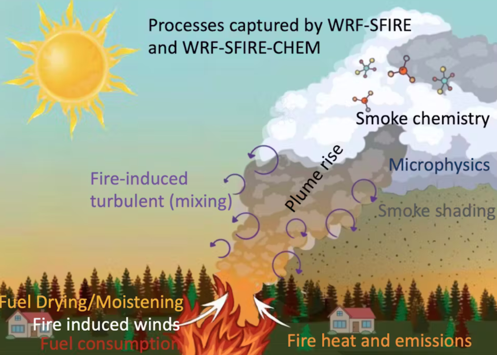
What happens next depends on the stability of the atmosphere. If the temperature cools rapidly with elevation above the ground, then the rising air will always be warmer than its surroundings and it will keep rising. If it rises high enough, the moisture will condense, forming a cloud known as a pyrocumulus or flammagenitus.
If the air keeps rising, at some point the condensed moisture will freeze.
Once a cloud has both liquid and frozen water particles, collisions among these particles can lead to electrical charge separation. If the charge buildup is large enough, an electrical discharge – better known as lightning – will occur to neutralize the charges.
Whether a fire-induced cloud will become a thunderstorm depends on three key ingredients: a source of lift, instability and moisture.
Dry Lightning
Wildfire environments typically have limited moisture. When conditions in the lower atmosphere are dry, this can lead to what’s known as dry lightning.
No one living in a wildfire-prone environment wants to see dry lightning. It occurs when a thunderstorm produces lightning, but the precipitation evaporates before reaching the ground. That means there is no rain to help put out any lightning-sparked fires.
Fire whirls
As air rises in the atmosphere, it may encounter different wind speeds and directions, a condition known as wind shear. This can cause the air to spin. The rising air can tilt the spin to vertical, resembling a tornado.
These fire whirls can have powerful winds that can spread flaming ash, sparking new areas of fire. They usually are not true tornadoes, however, because they aren’t associated with rotating thunderstorms.
Decaying Storms
Eventually, the thunderstorm triggered by the wildfire will begin to die, and what went up will come back down. The downdraft from the decaying thunderstorm can produce erratic winds on the ground, further spreading the fire in directions that can be hard to predict.
When fires create their own weather, their behavior can become more unpredictable and erratic, which only amplifies their threat to residents and firefighters battling the blaze. Anticipating changes to fire behavior is important to everyone’s safety.
Satellites Show Fire-Created Weather Isn’t So Rare
Meteorologists recognized the ability of fires to create thunderstorms in the late 1990s. But it wasn’t until the launch of the GOES-R Series satellites in 2017 that scientists had the high-resolution images necessary to see that fire-induced weather is actually commonplace.
Today, these satellites can alert firefighters to a new blaze even before phone calls to 911. That’s important, because there is an increasing trend in the number, size and frequency of wildfires across the United States.
Climate Change and Rising Fire Risks
Heat waves and drought risk have been increasing in North America with rising global temperatures, more frequently leaving dry landscapes and forests primed to burn. And climate model experiments indicate that human-caused climate change will continue to raise that risk.
As more people move into fire-risk areas in this warming climate, it’s not surprising that the risk of fires starting and spreading is rising. With fires come cascading hazards that persist long after the fire is out, such as burn-scarred landscapes that are much more susceptible to landslides and debris flows that can affect water quality and ecosystems.
It’s important to remember that fire is a natural part of the Earth system. Communities can reduce their vulnerability to fire damage by building defensible spaces and firebreaks and making homes and property less vulnerable. Firefighters can also reduce the surrounding fuel loads with prescribed fire.
As fire scientist Stephen J. Pyne writes, we as humans will have to reorient our relationship with fire so we can learn to live with fire.

Interesting article. I was struck by this:
George Tsakraklides makes an even broader and more alarming point: climate science is “dead.” By that he means:
So problems in predicting weather are not only increasing because of temporary, local effects like massive forest fires, but also globally and permanently because of reaching tipping points, changes in air and water currents etc. Just as the weather is getting more dangerous, it’s getting tougher to prepare in advance because of this increasing unpredictability.
Numerical weather prediction models use the basic physical equations which govern atmospheric behaviour to predict tomorrow’s and next week’s weather. Therefore, a warmer planet is not fundamentally more unpredictable in the short term. If this were the case, meteorologists who forecast the weather daily would be seeing the models becoming less reliable, which is not happening. (I am a meteorologist.) However, longer term weather patterns (climate) are changing.
Usually the difference when you go higher is around 3.5 degrees cooler per 1,000 feet of altitude gained, but in the midst of our heat dome last month, it was 112 degrees on the turn to Mineral King on Hwy 198 @ 1,000 feet, and 98 degrees @ Mineral King Valley @ 7,800 feet.
A piddly 2 degree difference per 1,000 feet gained~
And short-term numerical weather prediction models would have accurately modelled it.
Completely agree; however, I do not have faith in the current model treatment of wildfire aerosols (and their contribution to atmospheric stability by depositing heat at altitude).
That’s an interesting point. Hard to find any good news on the climate these days. On the other hand, bad to terrifying has plenty on offer. This Arctic News post from yesterday has a mesmerizing five day time-lapse video of enormous chunks of sea ice breaking up and away from the north coast of Greenland (the speed of the event being the point). There’s also a truly depressing image of an undeniably contorted/deformed Jet Stream. Sigh.
Good to “hear” your voice. You’ve been on my mind.
Instability aloft should be increasing over the next few days along portions of the west coast with the increasing temps. This gives those fires that have been mostly quiet with slow growth an opportunity to punch through the smoke and inversion layers and form a big column. Leading to what is described above.
It’s not like the Park Fire or the Jasper fire need a push. This next week could get very bad.
The seemingly whimsical nature of areas left unburnt in the midst of an obvious maelstrom that took out everything around it, always fascinates me when I feast my eyes upon it later, and more common than you’d think.
My only experience with fire tornadoes came at Burning Man, where vortices whip off what’s left of the Man in the later stages of it burning to the ground.
Around 2007, I watched them whip off the man one after another for 15 minutes and they screamed on the ground as each one scooted by at a high rate of speed for about 150 feet and then they were gone.
Here, watch a video of it:
https://www.youtube.com/watch?v=EBkes7WCZDg
“… the precipitation evaporates before reaching the ground.”
Just to expand on this phenomenon a little, even without a fire driving the process, precipitation can evaporate before it hits the ground when humidity is very low, especially when the air is hot as well.
The now-moist air is heavier and it accelerates downwards, pushing the lighter, drier air beneath it to the sides and creating wind gusts, producing wind storms with velocities beyond 60mph. These wind storms further increase fire hazard and risk under the already arid conditions during which this effect occurs, and they’ll feed fires of any origin and accelerate their spread. Then, even a single strike of dry lightning sets off an inferno.
We’ve been seeing these heat-driven wind storms more and more frequently in New Mexico in recent years, although the air has been moister this year. In 2024 we’ve had fewer wind storms, but more thunderstorms. Nonetheless, catastrophic drought conditions persist across the Southwest.
Most fire devils are less than ten feet tall and are caused by heat differentials at the surface level. The upper atmosphere has nothing to do with it.
They are far more common during firing operations (prescribed burns and burning out from containment lines on wildfires) than as a result of natural fire behavior, and can happen with or without significant wind.
Thank you for following climate change issues on your site. I like to see these articles, as well as reports on the diabolical antics of the high finance carnivores. I also occasionally re-read E-Conned. I don’t know if it’s ok to mention this, but as a resident of California’s Sierra Nevada foothills for 25 years, we have gone through several wildfires and I like the articles from The Lookout – Talking Wildfire with Zeke. He kept us informed and sane through a couple of events. He also has a good story on what would happen if the dams/levies in Northern California had a catastrophe all at one time. Pardon me or delete this post if not ok to mention. Thank you.