By Lambert Strether of Corrente
Patient readers, I apologize for being slow. I just bit off more than I could chew! Still, I hope the conclusion has merit. –lambert
Hurricane Helene was a brutal force. Taking loss of power as a proxy for damage, this map from PowerOutage.us shows how bad it was:
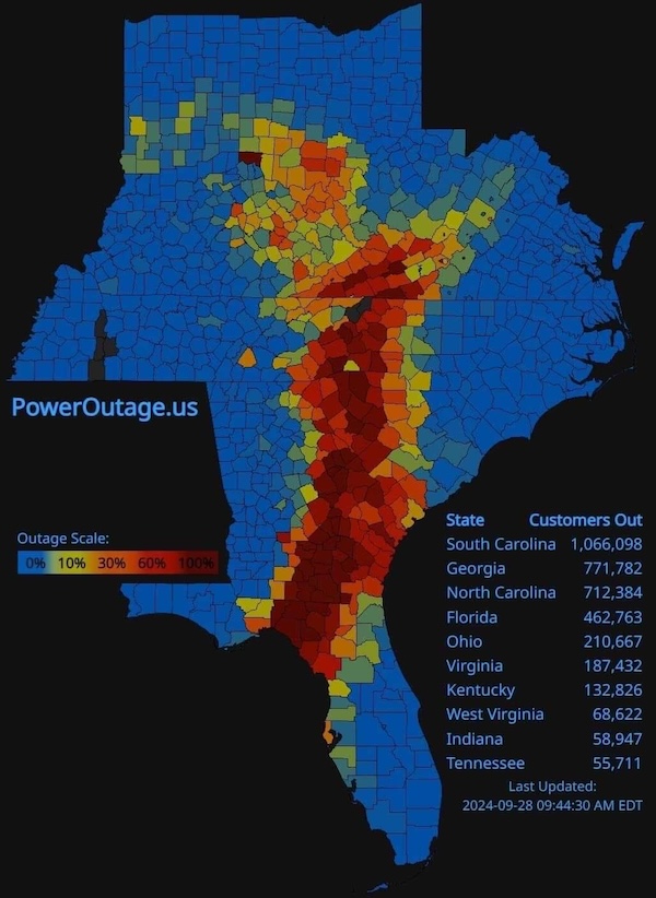
Red is bad. That’s a lot of red. In this post, I’m going to examine the Helene’s effects on Western North Carolina (WNC) only, and not other states in Helene’s path, partly because my academic family had a connection with Duke, and so I have childhood memories of the state, but mostly because the relationship between topography, demography, voting patterns, and the impact of Helene presents attractive possibilities for political analysis of a critical swing state that I did not see elsewhere (analysis that may apply to other Appalachian states, but I don’t have time to do that research). Damage to two institutions of national, even global significance — the National Centers for Environmental Information, and the quartz mines of Spruce Hill — is described in an Appendix.
North Carolina Governor Roy Cooper (D) described Helene’s impact in his letter to President requesting disaster relief:
Hurricane Helene entered the Florida panhandle as a Category 4 hurricane and moved northward impacting North Carolina with significant, damaging, and lifethreatening flash flooding across the western portions of the North Carolina mountains.
Widespread, catastrophic flash flooding is being experienced across the Blue Ridge Escarpment. Rainfall amounts through midday, Friday, September 27, 2024, have reached up to 20 inches in some locations creating power outages, major highway closures, major transportation stoppages, and the need for rescues and evacuations. Numerous landslides, with large damaging debris flows and slope failures, are occurring along the Blue Ridge Escarpment and in western North Carolina. Tornado watches are in effect for Eastern and Central North Carolina. Wind gusts reaching 35 mph are ongoing and isolated tornadoes have been reported throughout the State. Two deaths have been confirmed in North Carolina due to weather-related impacts.
Numerous river gauges have rapidly climbed above flood stage, with seven rivers (French Broad, Swannanoa, Pigeon, Broad, Catawba, South Fork Catawba, and Yadkin) at major flood stage and eighteen at moderate flood stage. Tropical Storm Helene has caused widespread damage including downed trees and flooding that blocked roadways, damaged residential structures and businesses, and caused at least 900,000 power outages and climbing. The investor-owner, municipal, and co-opt utilities have reported significant damage to the electric infrastructure in western and portions of central North Carolina and assessments are ongoing. Communication services have been degraded or are completely unavailable.
(Remember that word, “mountains.”) Helene’s effects have been discribed as “apocalyptic” “biblical devastation.” “The worst flooding in a century” has put both dams and water supplies at risk (and floodwater is unhealthy, not to say toxic). More than 400 roads are out, including I-40, the East-West artery of WNC, not that cars could gas up anyhow, with gas stations closed. Besides the power outages mentioned by Cooper, cellphones are out, too (the towers having gone down), although ham radio still functioned[1]. As of this writing, 1000 people are unaccounted for, and the death toll is rising. And if Hurricane Ian is any indiction, WNC residents will end up being defrauded on their insurance claims. Meanwhile, gutted newsrooms have made media coverage miserably inadequate.
There are many, many images of damage, on the Twitter, but I picked this one of Hot Springs, NC. Hot Springs looks like a war zone:
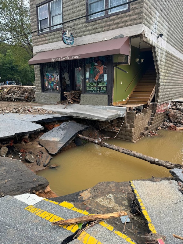
What struck me was that “Spring Creek,” gone mad in the storm, had ripped open the road to expose the town’s water system.
And now to those mountains.
How Topography Shaped Western North Carolina
Wikipedia (sorry) describes WNC’s topography:
[WNC]is the region of North Carolina which includes the Appalachian Mountains; it is often known geographically as the state’s Mountain Region. It contains the highest mountains in the Eastern United States, with 125 peaks rising to over 5,000 feet (1,500 meters) in elevation. Mount Mitchell at 6,684 feet (2,037 meters), is the highest peak of the Appalachian Mountains and mainland eastern North America…
Located east of the Tennessee state line and west of the Piedmont, Western North Carolina contains few major urban centers. Asheville, located in the region’s center, is the area’s largest city and most prominent commercial hub. The Foothills region of the state is loosely defined as the area along Western North Carolina’s eastern boundary; this region consists of a transitional terrain of hills between the Appalachians and Piedmont Plateau of central North Carolina.
Areas in the northwest portion of the Western North Carolina region, including Boone and Blowing Rock, commonly use the nickname ‘The High Country’. The term Land of the Sky (or Land-of-Sky) is a common nickname for the Asheville area. The term is derived from the title of the novel, Land of the Sky (1876), written by Mrs. Frances Tiernan, under the pseudonym Christian Reid. She often refers in this book to the Great Smoky Mountains and Blue Ridge Mountains, the two main ranges in Western North Carolina. The Asheville area regional government body, the Land-of-Sky Regional Council, uses this nickname.
WNC’s mountainous topography had several consequences.
First, historically, WNC’s terrain was not suitable for rice, tobacco, cotton, or plantations generally. This did not mean that slavery did not exist in WNC; but there were fewer slaves — i.e., Blacks — than in areas more suitable for the Slave Power’s version of Big Ag. From Asheville Watchdog:
By 1860, about 15 percent of the population of Western North Carolina was enslaved. Only a small percentage of the White settlers… owned slaves — about 2 percent of households, according to Katherine Calhoun Cutshall, collections manager, North Carolina Room, Pack Memorial Library — and of those, most owned one or two. The majority were owned by a handful of elite families, whose names are commemorated throughout the region.
They used their wealth and influence to help build Asheville and surrounding communities, supporting government, schools, healthcare, infrastructure, parks and other civic improvements, for which they were honored. But the wealth that lifted them to prominence was derived in large part by the enslavement and exploitation of Black people, entwining their many good deeds with the evil of racism [Or rather, the evil of property in persons].
2% of white households owning slaves contrasts to 45.8% in South Carolina; and 15% of the population contrasts to South Carolina’s 50%+, or Georgia’s 44%[2].
Second, WNC’s terrain makes for many small towns and a scattered population. From Renee Robinson on Twitter:
I need people to understand something with the news coverage regarding effects of hurricane Helene. There is a lot more to the NC Mountains than Asheville.
Boone, Blowing Rock, Banner Elk, Vilas, Sugar Grove, Elk Park, West Jefferson, Black Mountain, Swannanoa, Sylva, Cullowhee, Brevard, Bryson City, Hendersonville, Cherokee, Waynesville, Burnsville, Candler, Canton, Spruce Pine, Chimney Rock, Lake Lure, Linville, Marshall, Maggie Valley, Newland, Grandfather, Beech Mountain, Sugar Mountain, Old Fort, Morganton, Marion are just a few of the cities and towns that have been flooded and/or destroyed. The counties of Yancey, Mitchell, Avery, Ashe, Watauga, Transylvania, Burke, Caldwell, Alleghany, Madison, Buncombe[3], McDowell, Rutherford, Polk, Henderson, Wilkes, Haywood, Jackson, Macon, Clay, Cherokee, and Swain are devastated and in need of the same help, some even more.
Other counties that fall under various definitions of Western North Carolina include: Alexander County, Catawba County, Cleveland County, Surry County and Yadkin County. When these counties are added, they form a total regional area of roughly 11,750 square miles (30,400 km2). This makes the region roughly the size of Massachusetts. Western North Carolina holds 11% of our state’s population.
There are millions of people up there with no electricity, no communication, no water, and no way to get out or let rescue teams even know where they are. I am not taking anything away from Asheville and the utter destruction there or any other areas in NC that have damage. The level of destruction is unimaginable. But it’s not one or two cities or towns that are in need of help.
Matt’s Weather Rapport describes the isolation of the people across WNC:
I’m not just talking about a few backwoods hollows in the mountains. It’s virtually the whole region. The crisis is worsening, and I fear the death toll up there will skyrocket.
Much like Vermont, there’s tons of narrow, winding mountain roads in the region leading to an unknown number of houses, trailers, camps, resorts and local tourist attractions. The flooding and mudslides up there were cataclysmic. Since there’s no communications and electricity working, and nobody can get up there, nobody knows how many people have passed away, or are dying while they wait.
Small towns outside of Asheville like Castle Rock, Old Fort, Roan Mountain and Swannanoa have been almost completely destroyed. Accessing them will be harder than getting into Asheville.
Third, WNC’s elevation led people to believe it was safe, a “climate haven”:
Reminder that Western NC was considered a “climate haven” in the US.
Don’t think the impacts of climate change won’t reach you. Asheville is over 250 miles inland and 2,000 feet above sea level.
This isn’t normal and we need to address this as a climate crisis. pic.twitter.com/9HmTpXQw7b
— Nomadic Activist | Nicole 🌎 (@nomad_activist) September 29, 2024
That doesn’t affect election 2024, but it is one of life’s little ironies, eh? Now let’s turn to truly important, contemporary affairs: Politics.
Western North Carolina, Hurricane Helene, and Election 2024
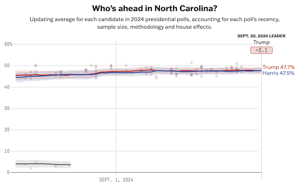
As readers know, North Carolina is a swing state, one of the states where a few thousand votes either way could determine the outcome of a Presidential election. It’s currently tied (within the margin of error). From Project FiveThirtyEight, though other pollsters agree:
Here is Joe Biden, juxtaposed by a Republican source: At the top, he’s dispensing largesse to Ukraine; at the bottom, he’s answering a question about disaster relief:
"$2.4 billion aid to Ukraine" vs "No more aid for Hurricane Helene" – 3 days apart pic.twitter.com/zA2CxzNPiG
— End Wokeness (@EndWokeness) September 30, 2024
The optics in the bottom panel are horrid: Biden, questioned on his relief efforts for devastated states, looks angry and hostile, and snaps that he’s sent “a significant amount even though they didn’t ask for it yet.” With two swing states in Helene’s path — George and North Carolina — reeling from an apocalyptic event in an election year, and he can’t work up any other emotion than tight-lipped annoyance? Oh well. That said, the real issue here is whether, in fact, the generally molasses-brained Biden Administration delayed relief, or not.
The Republican narrative is that “our goverment” delayed[4]:
Ashville, NC is getting the same treatment as Maui from our government.
Legacy media is MIA. pic.twitter.com/jX5ZA26k4f
— Spitfire (@DogRightGirl) September 29, 2024
But let’s go to the tape. There are two ways that a disaster is declared, says FEMA. The first is an Emergency Declaration, declared by the President, with a top limit of $15 million (this is the “significant amount” Biden sent more or less immediately). The second is a Presidential Disaster Declaration, which triggers FEMA, but which a state must request. Helene roared through on September 26-27; Governor Cooper made his request on September 27; President Biden granted it on September 28. Now, there may be plenty of reasons to quarrel with FEMA’s performance in the coming days, but as far as setting the wheels of government in motion, I don’t see a difficulty with the Biden Administration. (Sadly, the Republican spokesman on this issue is gubernatorial candidate Mark Robinson, who has his own issues.)
Campaign trivialities aside, how will Helene’s devastation affect voters on 36 days from now? Here is where the topography and demographics of WNC come into into play. Recall first that owing to its topography WNC is more white (that is, less Black) than the rest of North Carolina. Second, WNC is less educated, and more poor, than the North Carolina average. In other words, WNC is Trump Country (modulo the Trump voters who are golfers, crypto bros, financial barons, and so forth). A map from the 2020 Presidential election shows this clearly:
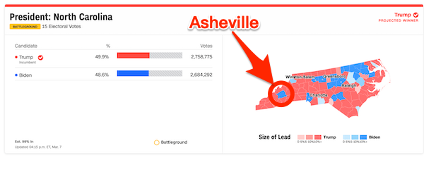
Asheville (population 94,589), with its eleven area colleges, vibrant arts scene, and Biltmore estate (now underwater) is the quintessential Blue City in a sea of Red.
Now let’s ask ourselves which voters in WNC are most likely to be able to make it to the polls and cast their votes, 36 days from now, based on their respective terrains. For the city of Ashville: I would imagine that one way or another, I-40 will be opened as soon as possible. Voting locations in schools and churches are concentrated, and one can be easily substituted for another. Some voting locations may even be within walking distance. Power and communications will also be opened — AFAIK, Internet service at the Asheville town library functioned throughout — not least so that rescuers can fan out from Asheville to more remote locations. For the mountains of Trump Country: Miles of winding roads will remain closed. Voting locations are far apart, and thinly scattered, so that substitution is not easy. Many voting locations can only be reached by car. Power and communications will be restored more slowly. The net result will be that most voters in Blue Asheville will be empowered relative to many voters in Trump Country (no matter their desires. It doesn’t matter if you’d crawl over broken glass vote for Trump if “you can’t get there from here”).
Conclusion
Trump won North Carolina in 2020 by a margin of 2,758,775 – 2,684,292 = 74,483. Even if Hurricane Helene takes away only (say) 10% of those votes from Trump Country, that could be enough to swing the state to Kamala, if she does a little better in other parts of the state. Continued volatilitiy!
P.S. North Carolina readers, please correct me. I really enjoyed reading up on the state!
NOTES
[1] From QRPer:
I’ve heard it all my life: when all else fails, ham radio still works. And let me tell you, it’s true.
Throughout the storm, our normally quiet repeater systems were buzzing with activity. The traffic became very organized, with hourly nets helping pass messages to family and friends, sharing detailed on-the-ground reports, and identifying areas where help was needed. Even though our emergency services are overwhelmed, we’re able to connect with them via amateur radio networks like ARES.
Right now, being a ham feels like a superpower. For many people, it’s the only form of communication that still works.
[2] The mountainous terrain also permitted a degree of social experimention. From WNC Magazine, “The Happy Land“:
It began, the stories say, with a search party of sorts: a caravan of emancipated African Americans traveling up from the Deep South, looking for a place where they could embrace freedom, safety, and self-sufficiency—a haven for putting down roots and building a new life. They found it in the southern reaches of Henderson County, where they established the Happy Land, or perhaps the Kingdom of the Happy Land—accounts differ on the precise name. For decades following the Civil War, a singular communal experiment existed, and it became the stuff of legend.
Chronicles of the Happy Land have proved as divergent as the paths that brought those freed slaves to their destination. Little of their venture was written down at the time, but stories added to the record decades later have helped paint a picture of how the kingdom’s residents came to their unique way of living, how they prospered, and how their saga was ultimately cast to the winds of history.
In Western North Carolina’s higher elevations—’mountains that stretched for miles without habitation, where newly freed slaves might find a small piece of land to call home.
[3] The term “Buncombe” did indeed originate from Buncombe County.
[4] I don’t think the Maui analogy is a good one. The topography and the scale were completely different; and the failures were local, not Federal.
APPENDIX National Institutions Affected
First, NOAA’s National Centers for Environmental Information. From Axios:
Hurricane Helene’s severe flooding knocked offline the top tracker of U.S. and global climate data, including of extreme weather.
The National Centers for Environmental Information also maintains and updates NOAA’s list of billion-dollar extreme weather and climate events.
According to NOAA, which runs NCEI, the building currently has electricity but no running water, and won’t be fully occupied until services are restored.
In a statement to Axios, NOAA also said the center’s network connection is down, an outage expected to last days.
Second, the quartz mines in Spruce Pine, NC. From the Verge:
[Helene’s] devastation also reached the small town of Spruce Pine, which is home to the purest quartz on Earth.
Spruce Pine’s high-quality quartz is an essential ingredient in the chipmaking process, as it’s the only naturally occurring source of the ultrapure mineral. The quartz mined from this area is used as a crucible to melt polysilicon, which is then used to produce silicon wafers — the base of a semiconductor.
Even though it’s possible to produce pure silicon from the quartz found in abundance elsewhere in the world, it takes a considerable amount of time and resources to do so, according to a 2018 report from Wired. Hurricane Helene dumped more than two feet of rain on Spruce Pine, with several reports on X showing extreme damage and flooding that has made roadways inaccessible, while many people in the area are without power.
But with communication in the region still extremely difficult, it’s been hard to determine whether the two mining companies that operate in the town — Sibelco and The Quartz Corp — are affected….
As pointed out by Wired, a 2008 Spruce Pine fire ‘all but shut off the supply of high-purity quartz to the world market, sending shivers through the industry.’ If the two mines sustained damage this time around, the impact could be even greater, given the world’s increased reliance on chips to make phones, processors, solar panels, and other technology.


Quick correction Lambert- the picture of Spring Creek Tavern is in Hot Springs NC.
Took a break from hiking the AT in Hot Springs and stopped at this pub. Heartbreaking.
Likewise. Very, very sad.
The complaints I am hearing are that there are no military assets being deployed to help. Ft. Bragg is very close by and they have a lot of helicopters. Seems like helicopters would be pretty useful.
Getting military support may require more than just a presidential declaration of disaster, thanks to the Posse Comitatus Act. (I understand the abuse of power potential, but noncombat, non-law enforcement support should be a no-brainer.) National Guard from NC is being used, plus a unit from CT is in the area.
Were I president, I would consider using it, but, were I president, I would have gotten the Civil Reserve Air Fleet to help pick up people from Afghanistan, something neither Trump nor Biden appears to have considered.
This is a how many divisions does the pope have issue. Along as they aren’t policing, who gives a hoot?
The troops went into San Francisco after the 1908 earthquake. Teddy want impeached.
My guess is they are short materials n service to Biden’s genocide and would embarrass themselves
Yeah, I’m thinking of transportation, search, and rescue not law enforcement.
Waffles Houses closed. If that doesn’t warrant the army, I don’t know what does.
not just closed but boarded up! end times!
Great timing. Tennessee National Guard sent to rescue Israel’s ass last Thursday.
https://www.tn.gov/military/news/2024/9/26/tennessee-national-guard-task-force-deploying-to-middle-east.html
Kamala’s seen making a staged phone call with FEMA director, who shows up wearing a leather jacket at press conferences. Harris forgot to plug her phone jack in, purely photo op.
Biden’s asking Americans to help those in need. If you aren’t seething mad, you aren’t paying attention.
Helicopters
https://www.nationalguard.mil/News/Article-View/Article/3919179/national-guard-assists-with-hurricane-response-in-southeast/
https://www.thebaltimorebanner.com/national/north-carolina-hurricane-helene-rescues-3NJ4ZYMIDNGAFBJBD7FM2QYOZM/
National Guard helicopters, not Fort Bragg, interestimg. I assume the legalities are different. Or maybe the Israelis are gonna need the Fort Bragg helicopters, who knows…
There’s a comment from flora about legal restrictions today on Links
https://www.nakedcapitalism.com/2024/09/links-9-30-2024.html#comment-4108823
More helicopters (these are also NG units)
https://x.com/NCNationalGuard/status/1840516287522390154
Ft. Bragg (renamed Ft. Liberty) isn’t that close, over 200 miles by helicopter. About the same distance to the North Charleston Air Base in SC.
I surely don’t know the rules about using the military, but it shouldn’t matter. People need help – and now – end of story.
When did rules matter anyway?
Since it depends on who benefits and who don’t I guess…
This country makes me sad.
the government can’t use the military to enforce laws—is the only law that I’m aware of.
If you want my/the internet’s tin foil hat—–the 101st Airborne is too busy planning for possible contingency operations in Lebanon (99.9% evacuating Americans) that the Pentagon can’t spare the bodies
The 101st is in Kentucky. You are probably thinking of the 82d, in particular 82d combat aviation brigade 3rd Bn would seem most task-suitable if they are in garrison. Today is the first day for FY25 so should be money for fuel etc.
BINGO.
since when cant the military help as a supporting role without violating the law? if theyre not directly interacting with the public than whats the problem? airdropping water, food, medical supplies, helping build additional shelters, help with cleanup, helping search and rescue, etc.
i would absolutely not support them acting as cops unless something extremely serious somehow required it, and that would be with a ton of caution and skepticism.
It made many people dead, so you are not doing that bad.
My wife was due to send a bio sample for lab testing to Genova. Didn’t know something so asked their website. Ooops, off line. Why?
Genova is in Asheville, NC. Google Earth shows them right next to a river. Going to be down for a while…..
Also, thanks Lambert for the xclnt update.
Thank you very much for this post
I really appreciate all the detail.
Thank you, Lambert. This is excellent work.
Biden’s response to the reporter’s question about aid to the area was appalling. He exhibits no compassion whatsoever. He can’t even pretend to care. What a sad excuse for a human being he is.
Just like Obama when asked about how the Deepwater Horizon blowout cleanup was going, or Junior Gush when asked about how things were going post-Katrina in New Orleans.
One wonders if sad-excuseness-for-a human-being is a necessary part of “what it takes” to even become President.
I don’t wonder about that any more.
Trump, well, we know Trump, while newcomer Harris ticks all the boxes, and then some.
this specific thing is going to cost harris the election. i was already betting on trump (though i hate him), now im convinced he will win. ugh.
how does the democrat party manage to screw themselves so hard with absolutely no assistance from the republicans?
A number of the small communities outside of Asheville, particularly college towns like Cullowhee, had more support for Biden than Trump. Maybe not enough to swing counties, but still significant. In addition, the Cherokee may be backing Harris due to Trump’s support for the Lumbee gaining federal recognition being a threat to their casino business.
On a broader scale, Trump has already made this into a political issue with his recent visit to Valdosta. He’s also gotten Franklin Graham to stand with him. (The Graham family is influential in parts of Western NC.)
https://www.politico.com/news/2024/09/30/trump-hurricane-helene-campaign-00181751
Biden plans to visit Asheville on Wednesday.
Good points on the Cherokees and Graham. Valdosta is in Georgia, though. Which I guess is a signal….
Thank you Lambert. I don’t see any upside in this for Harris. This is a disaster for team blue. I’m wondering how many climate refugees were freshly minted.
Not if Team Red can’t get to the polls.
But what you just said, really, is that climate has suddenly become a political issue. ‘Tis a consummation devoutly to be wished.
I think there is a bigger picture here.
How many undecideds may see this and either choose not to vote, or go third party?
> How many undecideds may see this and either choose not to vote, or go third party?
In essence, you’re urging that Helene could be Harris/Biden’s Katrina. I’m not sure that’s doable (a) because the Appalachian’s aren’t New Orleans, part of which is that (b) the suffering is not visible, like all those poor souls trapped in that stadium, but also (c) the national press was all in to get Bush, and they are not all in to get Harris/Biden. Further (d) I haven’t seen crisp messaging on this either, though we will see if Vance comes up with anything tomorrow. (I haven’t seen crisp messaging from the Democrats, either, to be fair.)
I don’t know how Vance can make this a winner for Rs. It would be a good time for a come-to-Jesus talk about climate change, consumption, oil addiction, etc., but the Rs are locked in to climate change denial. They also demand budget offsets every time there’s a disaster whose needs exceed the FEMA budget (which is any disaster at this point in the fiscal year). Demanding that greater resiliency be built-in is a no-go because that would require the dreaded government regulation.
He could try the Franklin Graham “God is punishing ‘Murca because of the gays” routine, but I think that’s very unlikely to win over any new voters.
Note that I find Democrats love of electric cars and PVs no better. There is no major party politician willing to speak the truth about this issue, which is that until we end this unrelenting push for economic growth and the related love for the “middle class lifestyle” that consumes obscene amounts of energy per person, we can’t even begin to address the problem because any fix is swallowed up by The Next Big Thing like energy guzzling AI.
Vance doesn’t have to do anything except point at the current administration being uncaring and ineffective while bearing the responsibility of handling things. Again, this is a disaster for team blue. Literally. Supposedly they are in charge.
All he’s got to do is juxtapose the Israel and Ukraine aid with the crumbs available for disaster relief and he’s get the visceral reaction he needs.
What if they gave an election and nobody came?
A fair case could be made that at both State and Federal levels, response was unevenly distributed in a way that affects the gerrymandering. The polling (and thus potentially election results) must be delayed while this inequity is resolved.
What would SCOTUS do?
> A fair case could be made
I don’t think easily. There’s no precedent that I can think of .
You have a point on precedent. I couldn’t find cases that weren’t in the 1800’s, but there are resources from the last election cycle, the first since the Before Times:
National Constitution Center:
: At least 45 states have statutes that deal with election day emergencies
: Absent a clear winner of the presidential election on January 20, the Speaker of the House would serve as Acting President under the current succession law.
This story gives another reason to hate early voting:
> Hurricane Helene scrambles mail and early voting plans in North Carolina
Fodder for lawfare. But it looks like North Carolina could delay and it wouldn’t stop the Presidential from being decided. Probably.
> This is a disaster for team blue
To respond again: Only if Team Red makes it one. Not seeeing it so far. And it’s got to be quick; 35 days to go (as I scream into the wind, while Trump sells coins and the Biden/Harris tweet photos of themselves working the phones). Drives me nuts. Get serious!
Team blue gets to own Helene, whether they want to or not. Everybody is watching. Will the Feds be able to mount an effective response? My wife is reading to me that Musk is trying to do something with Starlink. Score one for the other team. How long before we hear “Heck of a job Deanne.”
Un-serious people cannot and do not become serious. I give you our candidates. Q.E.D.
Mutual Aid
Note: I don’t know how current the map is or anything about the aid groups in the thread. Just looking for the helpers.
Crowd sourced Interactive map of places open in western NC
https://www.citizen-times.com/story/news/2024/09/29/asheville-flooding-where-to-get-gas-food-and-water/75441687007/
Twitter mutual aid thread
https://x.com/antiracistsouth/status/1840739294916301095
There may be lots of small towns but the population of the region is overwhelmingly in Asheville?Hendersonville and outlying and believe me they have lots of cars and ways of getting to the polls. For years they’ve been widening the local freeways to handle the crush.
So I’m not sure how this affects the tactical level. On the strategic level it merely reinforces the notion of a situation out of control both domestically and overseas. The hard core Dems and Trump haters are going to vote Harris no matter what/. For independents though she doesn’t strike me as having much to offer if anything. We heard the NC is going purple claim last time and it didn’t. Arguably Harris is a weaker Trump alternative in 2024 than Biden was in 2020.
> There may be lots of small towns but the population of the region is overwhelmingly in Asheville?Hendersonville
As of 2020, the total population of WNC is 1,149,40 (11% of North Carolina’s total population).
Population, Ashville: 95,056 (2023). Ashville’s county, Buncombe: 275,901 (2023).
Population, Hendersonville: 14,157 (2019). Hendersonville is in Buncombe Country, and so included in the total above.
So, hardly “overwhelming.” Indeed, I would argue that the absence of a dominant metropolis is a feature of WNC (indeed, of NC). Contrast New York City (8 million) vs. New York (20 million). Of course, a city may dominate culturally and politically, but not in population, like Boston. That metropolitan characteristic is missing in North Carolina too.
Sorry, Lambert, Hendersonville is the county seat of Henderson county. Asheville/Buncombe county is right next door and the Asheville airport is at the county line and serves Hendersonville equally well. Hendersonville is for folks like us who like WNC but don’t want to pay high Asheville property prices.
Thank goodness we’re not there right now, but I’ve been following the situation and I understand our vacation home inside the Hendersonville city limits MIGHT get power by Friday. I also understand there’s a “boil water” advisory even though the city water treatment plant has returned to near full capacity, but there are still many water main breaks that result in low system pressure, creating backflow danger.
This is excellent work all through; thank you.
[lambert blushes modestly]
Another article about the Happy Land.
https://scalawagmagazine.org/2019/09/black-appalachia-kingdom/
What a miserable, dissected corpse Biden is. Doesn’t he even realize that he could use his Presidential powers to give aid and relief to millions of registered voters a few weeks out from a Presidential election? Does he think that it was only Trump country but was hit by that hurricane and can’t be bothered about them? Katrina derailed the Bush regime because Bush couldn’t be bothered about the people slammed by that hurricane and it may very well be a repeat with Helene and Biden’s Democrats.
He is not the president, so he doesn’t care. Thank you, Team Blue.
The governors of the affected states should send their aid requests to Zelensky and Netanyahu, they could easily spare a billion each from all the generous support the U.S. provides to them. Pay it forward!
Thank you for posting, on what is or had been a delightful place to visit and to hike, since I relocated into nearby Spartanburg, SC ( close enough to it but just a wee miles outside of that city proper ). I even have distant relations near the Weaverville area ( I think ) & frequently as a young kid my family visited Greeneville, TN (which meant drive thru Asheville or drive thru Boone).
Now to put something out there for those in the broader Spartanburg county and still in need of power or basic utilities. Starting earlier today I got notice the National Guard was going to hand out goodies for those in need of it ( I think water and maybe MRE ).
South Carolina is different yes but the impact of this storm may linger to end of the week. I don’t have a great big circle of those I’m consistently texting or asking how it goes..But it seems I got the good straw with power and water and so forth. Downed trees are abundant and will be the ongoing nuisance for the line workers and crews.
I’m also wanting to avoid chirping about ” how good ” it’s supposedly going in this part of SC. It’s better by comparison but I put the emphasis to the phrase ” it’s a long uphill climb to label this a success “. My two cents only.
Here in Greenville, some areas are with power, some, like me, are without. (And I’m in a moderate suburb neighborhood, with a rich golf course nearby.) Old trees may be a factor in how the power was lost, in addition to the substation damage.
My job is closed as well. There is power along the main road in both directions from them within a mile, but not for them. (A nearby bank and restaurant have generators. The nearby mall is home to a base camp for utility workers from all over. Also at the mall is a traveling collection of pop-up shops from a high-end mall in Miami- but they aren’t open.)
My volunteer organization has not been called up, at least not in my area. Our home base has no power. Saw a trailer for the SBC disaster relief group…and it was sitting behind a church gym that was being used for a skate park, and it didn’t look to be used. Duke energy is estimating power to return by Friday night for us.
Things are rough in some ways, but we are in better shape than NC.
Our local NWS office just cancelled the event they planned for Saturday. They can use the rest after all their work warning Western NC and SC.
Nearest to me there are multiple major chain locations. McDonald’s remained dark Monday evening, but to the good yesterday I saw the Zaxby location across the 4 lane road was doing service again. Most everything remained closed on Sunday, to my knowledge only the gas stations or the Waffle House. Lived here since 2016 and state highway SC 9 is only becoming more travelled each year.
I’ll wonder if this scenario taps the brakes for a “hot minute” in economic growth and the influx of newly minted SC citizens.
I am worried that the destruction of many houses in W. NC will only deter the flatlanders from moving in for a cup of coffee, and then when they resume, there will be even less supply, sending prices on another rocket ride north.
At some point though it has to end. Half a million dollar shacks with no power or running water?
‘The Nolichucky river crested the Nolichucky dam and washed away every bridge that stood in its path.’
https://www.bitchute.com/video/BbsmHcBC9Whm (1:16 mins)
Wow. Afterwards they are going to have to check Nolichucky dam for structural stresses to see if it has been weakened.
“The Nolichucky river crested the Nolichucky dam…”
This brings up what strikes me as a useful question; how important is precision in weather forecasting? There is now a forecasting system that is very, very fast, extends accurately as long as 7 days and covers weather in sections about 3 kilometers or 1.864 miles: “Pangu”…
https://www.nature.com/articles/s41586-023-06185-3
July 5, 2023
Accurate medium-range global weather forecasting with 3D neural networks
By Kaifeng Bi, Lingxi Xie, Hengheng Zhang, Xin Chen, Xiaotao Gu & Qi Tian
https://www.scmp.com/news/china/science/article/3230612/why-european-weather-agency-using-chinas-artificial-intelligence-model
August 13, 2023
Why a European weather agency is using China’s artificial intelligence model
The European Centre for Medium-Range Weather Forecasts is working with Chinese tech giant Huawei to launch an AI-based forecasting system
AI models have been described as the ‘quiet revolution’ of weather forecasting, which could be a game-changer for the industry
By Zhang Tongin
Beijing — An intergovernmental organisation in Europe is working closely with a Chinese tech giant to apply artificial intelligence (AI) to weather forecasting.
The European Centre for Medium-Range Weather Forecasts launched a Chinese AI model capable of predicting global weather on its website late last month.
The model, Pangu-Weather, was developed by Huawei Technologies…
I hope no transformers got wet amongst the general destruction. Wait time for replacements is 2-5 years.
A local company is majorly involved in providing refurbished, replacement transformers around the world. They are making a lot of money.
Unfortunately, they are also run by right-wing religious types, with Bible verses on banners in their ads, and theological debates on their internal discussion network. (One of their major locations is Moscow, Idaho, known for a religious sect that makes Donald Trump look like a feminist.)
One of the founders was forced out of the company, and is suing them, alleging that they over reported his income from the company, this sticking him with a huge state and federal tax bill.
The US ambassador to Ukraine boastfully tweeted a while back about the number of transformers the US had sent there to help restore power after Russian attacks. Wonder if the US can ask for them back, or if they have already been destroyed.
https://x.com/lebanonhedge/status/1841056881126605251/photo/1
I-40 has collapsed in several spots and there could be rockslides (typically west of Asheville). “As soon as possible” will be several weeks before I-40 is open through the mountains. Asheville will be accessible from the east relatively quickly though.
Thanks for the link. I know the area well since there’s a presumably now not accessible National Park campground near the break.
As Lambert says one of the biggest problems is getting good information from our attenuated local media.
> I-40 has collapsed in several spots and there could be rockslides
I was picturing pontoons or some sort of military construct for a temporary bridge (though I don’t know if the National Guard has that capability or not).
I-40 through the mountains close to the NC / TN border has been closed for long periods within the past few years. There are (longer) alternative routes for interstate traffic and NCDOT has generally chosen to keep the road closed rather than trying to rebuild while traffic is passing through.
Looking like it will be “several months” (not weeks) before I-40 and hundreds of western NC roads are passable.
The North Carolina Department of Transportation has two really nice interactive websites for viewing current conditions:
The number of posted road closures in western North Carolina is jaw dropping. I’ve been randomly clicking on closures and I have only seen a couple that are expected to be cleared before October 10.
Our NC tax dollars at work (I didn’t know the websites existed – thanks!)
Those tax dollars are headed to Redmond. The latter site is based on Bing. With compromised Internet service, the last thing you want to load is a fully interactive map. After it loads, there is a CSV download of closed roads.
The correct way to do this is a basic HTML page with that information in a table, and progressively enhanced with JavaScript for sorting and filtering, if your device has JavaScript enabled.
I guess no one thought, or cared, that this might be useful during a serious emergency with disabled or compromised telecommunications infrastructure.
But Microsoft gets a payday, at least!
> The correct way to do this is a basic HTML page with that information in a table, and progressively enhanced with JavaScript for sorting and filtering, if your device has JavaScript enabled.
[loud cheering]. There does seem to be an assumption that fast internet will always be available.
I didn’t think could despise Biden more. I was wrong.
I just heard Harris on the radio make a statement about the damage from Helene. She sounded like a drunk robot. Can’t even read a short script with any competence. Trump also spoke about Helene. At least he sounded like a real person speaking about a national disaster. He had a lot of strong feeling in his voice, for whatever that’s worth.
Like Screwball wrote above, this country makes me sad.
Is the Mellow Mushroom pizza place in Asheville considered Harris Country? Is the O.P. Taylor Toy Store in Brevard considered Trump Country? I stopped by both on a recent vacation and nobody confronted me to declare my affiliation.
The post explains the demographic and historical reasons for that designation. You would have to apply them to your particular locale (though Asheville clearly is not).
The disparity between funding Ukraine and funding ***Life Saving*** assistance for US citizans effected by Helene would apparently seem based on priorities. Trillions in Ukraine resources with a side of getting at Russian resources down the road.
Additionally Ukrainian nationals are expected to live like the people in the regions effected like Helene, so its a two’fer of social narrative and engineering = because neoliberalism = Die ….
The idea that either of the Corporate parties care about nationals is a joke ….
And if you get into an argument with a PMC adjacent Dem about this – just point out the obvious – Ukrainians don’t vote for US President in November.
Thanks for posting this Lambert!
I’m getting the sense that the PMC want to insure that the “wrong kind of Americans” don’t vote for US President either, one way or another. The hurricane might give them an excuse to disenfranchise a lot of people, if only indirectly (slow repairs to roads and other infrastructure, for example, to deny access.)
But as IM Doc pointed out in links page earlier today, people in disaster areas may not have places (or the usual places) to vote if services and infrastructure aren’t fixed.
> The disparity between funding Ukraine and funding ***Life Saving*** assistance for US citizans effected by Helene would apparently seem based on priorities.
Yes. This is the case that many Republicans are making (and I prefer to “Location ____ isn’t getting help, all because of Harris/Biden). The fomer is clear, and constantly reinforced in the newsflow by Democrats who consider it A Good Thing. The latter is neither (since all individual reports, from either side, are instantly challenged).
Although Democrats usually prefer to be seen “fighting for” while Republicans prefer “fighting against” funding for disaster relief programs neither “side of the aisle” has been doing the job, wherever they claim to stand on funding military support for Ukraine and Israel.
Congress was doing their shut-down dance last week, and they’re not in session now.
2023 Biden “calling for” disaster relief funding
https://www.politico.com/news/2023/09/02/biden-fema-funding-00113834
2024 – Not familiar with this site, but it’s “eenews by politico”
https://www.eenews.net/articles/lawmakers-stunned-as-disaster-funds-left-out-of-stopgap-bill-2/
The PowerOutage map shows all the signs of a neglected, aging, deteriorating infrastructure that experts have warned about for years.
Drones are a hot topic in the Ukraine war but they could be used to constantly monitor the transmission lines for indications of an incipient problem and weakness, and ensure preventive maintenance before a storm hits. After a storm they can be used to locate damaged lines quickly and assist search and rescue operations.
Upgrading the system to a “smart grid” with sensors to automatically shut down substations at the first hint of potential damage in order to protect the system and restore power quickly afterward.
Billions of$ for Ukraine and Israel but government could subsidize placing electric cables underground where it makes sense to do it. Germany and IIRC the Netherlands have nearly their entire transmission system underground.
There are newer telephone polls that are far stronger and able to withstand high winds that should be used everywhere.
The crumbling infrastructure should be a major campaign issue.
OK, I have to push back against the whole “climate haven” part of this narrative. The area had the same exact thing happen to it over 100 years ago, during the flood of 1916. And guess what caused it? A series of hurricanes. This is not a new phenomenon to the area. What is new is the large population increases to the area, with the population increasing by 50% since 1990.
And as I pointed out before Helene made landfall in Florida, Camille did this to Nelson County, VA in ’69. The eastern slopes of the Appalachians, from Georgia to Vermont, are no place to be. And the western slopes get hit when hurricanes come up through New Orleans.
Forget it, Jake. It’s Climate Town.
(But al ot of the same with wildfires in Cali with the population and structure creep)
Forget it, Jake. It’s Climate Town.
(But a lot of the same with wildfires in Cali with the population and structure creep)
With the discussion on how ham radios have shown their usefulness when all else fails, I’d like to bring attention to the availability of Baofeng handheld radios. Even with accessories they are under $100 and with the large whip antennas have real decent range. Enough range and power that it’s rankled some in the ham community because users don’t always go through the process of becoming a licensed hamster.
Many people in the wildfire world have personal sets just in case. Lots of programming help available on line and a good chance you could get all your local frequencies programmed.
There’s also a low-barrier to entry Technician ham “starter license” that’s offered that would introduce you to the right people for additional help.
I have friends who live in Roan Mountain on the North Carolina Tennessee Border. They live up high so no power, otherwise safe. Isolated? Cell service? Internet? Roads impassable? Bridges out? some all all of those in the area.
Update from Roan Mountain:
Well we fared pretty well. That and everybody had a chainsaw.
But there are many roads and bridges totally washed out and gone including roads on I 26 and I 40.
I am okay!! Al in a four wheel drive pick up truck and a chainsaw, and a can of gas, left Wilmington where he is working and 24 hours later got to me on the mountain. The next day we cleaned out freezer and gave our neighbors a lot of food, and our full gas cans for their generator, loaded food in coolers and were able to get to far better roads than he had had to go through. So now I am in our apartment in Wilmington with power, water, cell and internet.
….
Let that be a lesson: with 4-wheel drive and a chainsaw you can get pretty much anywhere
An important reason why rural Americans have trucks. Something not appreciated by city folk.
For those interested in on the ground updates Blue Ridge Public Radio is streaming regular coverage.
Local government sources and first responders. Some bits of remote reporting.
Community radio and hams are really feeling th3 communication gap. A reminder to have that hand crank radio on hand.
https://www.bpr.org/
For those interested in on the ground updates Blue Ridge Public Radio is streaming regular coverage.
Local government sources and first responders. Some bits of remote reporting.
Community radio and hams are really feeling the communication gap. A reminder to have that hand crank radio on hand.
https://www.bpr.org/
Here is a list of organizations helping on the ground and with air drops and air rescue.
https://www.bpr.org/bpr-news/2024-09-28/list-ways-to-donate-and-help-flood-victims-in-western-north-carolina-after-hurricane-helene
This decides the 2024 presidential election in North Carolina. Asheville notwithstanding, this is the deep red side of the state. And there is no way that very many of the residents will be voting in scarcely a month; it is questionable if they will even have power by then. If anything, Asheville, the blue part, will be up and running first, while the outlying red parts will lag. Chalk NC up for Harris.
I vote in Waynesville in Haywood County about 15 miles west of Asheville. Just tried to order my absentee ballot but it’s not happening because there has been no internet access since the storm blew through on Friday. I am a Stein voter.
Left Waynesville this morning as soon as I 40 east opened. With no internet since Friday and the only form of communication, text messaging, I found out about I 40 from a friend in Florida who texted me.
When I got access to the internet, I was amazed at what had happened within 5 miles of my house. Hazelwood, the quaint shopping district closest to me, was flooded.
Without the internet we relied on a gas generator which we shut down intermittently to conserve gas for electricity and a plug in Sony radio/cd player that was 20 years old for information. Glad I held on to it. It only worked in the basement on one station which with few professional reporters provided little info.
We lived for 40 years in Orlando. In 2004 4 hurricanes blew through in a matter of months. This was on par with the one that knocked down our 20 year old live oak from the roots. Strange times.
If I were in charge of the world, I would set up an effort to design and distribute a self-contained satellite-based internet backbone that could be used for emergency communications. The fantasy would be that households, communities, neighborhoods, homeowners associations, and other local entities could buy a small portable device that would allow communications with the outside world when other means had been cut off. This is well within our technical capability now, and it would be nice to see such a device selling for less than $100.
At the time of Hurricane Katrina, I worked for a company that made a satellite-based text communication system for industry. We deployed a bunch of Jeeps to Louisiana outfitted with these things and they showed their value immediately. They just parked one at key intersections in various areas and would do text messaging for all comers. They quickly became vital, and were frequently the only means of communication with the outside world since our other systems (phone, internet, local radio and TV) are quite brittle and will all fail in a prolonged emergency.
It made quite an impression on me at the time, and it would be vastly easier from a technical standpoint now due to improvements in technology and in satellite coverage.
As Lambert points out, ham radio operators can serve this role in some areas with good luck, but ham needs a local network of people with licences and equipment and some kind of disciplined arrangement since ham is only a physical layer and not a complete system. Individual people or groups that are stranded may not be able to make use of it.